
Mountain Biking
We are blessed here in the Ozarks with an abundance of Mountain Biking Trails to enjoy. We've listed several below with descriptions of what to expect and how to get there. We will soon be updating this section with maps and photos of the trails. If you have any good photos, or a favorite trail we've overlooked, please e-mail us.
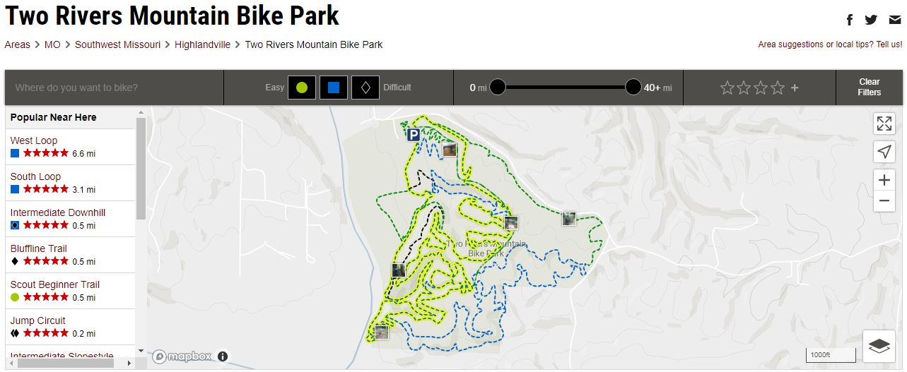
Two Rivers Mountain Bike Park
Two Rivers Mountain Bike Park is one of the best trail systems in the entire midwest. It has something to offer for everyone! The trail system boarders the James River and offers a combination of scenic river views and some great views over the valleys in the area. Two Rivers has around 15 miles of trails right now and they are still adding new trails. Along with the singletrack that they offer, there is also an intermediate downhill (possibly and advanced downhill coming soon), a beginner and intermediate slopestyle, a skills area, and a professional length disc golf course. Cell service isn't great around the area, especially in the valleys, but they have a signal booster and free wifi around the barn.
Sac River Trails
Trail description: The Sac River Trails were built by Mountain Bikers just for biking. The trails here are twisty and a lot of fun. Sac is a relatively small area, so you need not worry about getting lost. There are roughly 10 miles worth of trails and it is very close to town, making it an ideal destination when time is an issue. Sac River does get muddy after a rain or snowmelt so please use proper etiquette when the trails are wet to avoid widening them. These trails are moderate in difficulty. There are some small climbs, and they are somewhat rocky, but nothing overly challenging.
Directions: From Springfield, head north on Highway 13 (Kansas Expressway) about 2.5 miles. The entrance is on the left, and there is a sign pointing to the driveway.
Busiek State Forest

Trail Description: The trails at Busiek originate around what is basically a flat, easy fire road, with more difficult trails branching out from either side. These trails involve a lot of climbing and descending, and like most of our local trails, are rocky. There are a few creek crossings. Busiek is a multi-use area shared with hikers, equestrians and even hunters during season. Always yield the right of way to riders on horses so as not to spook them. Difficulty ranges from easy, for the fire road, to difficult for some of the rocky side trails.
Directions: From Springfield, take US 65 south about 15 miles. The entrance to Busiek is on the left at the bottom of a large hill. You will know you are there when see a left turn lane as it is the only left turn lane on that new stretch of highway.Hopefully, there will be a sign installed again soon at the entrance.
Chadwick
Trail Description: The Chadwick trail area is very extensive with over 100 miles of trails. It is recommended that on your intial few visits you avoid riding alone so as not to get lost, and so there is someone there if you are injured. At the very least, you should obtain a map until you learn the trails. We advise going with someone familiar with the area who can steer you to the ideal trails.
The trails at Chadwick are shared with motorcycles and you should exercise caution to avoid an accident. You can hear them, but they can't hear you. It is also required that you obtain a permit to ride here. They are $5 and can be purchased at Kay's store in the town of Chadwick.
These are mostly expert level trails with lots of large rocks, tree roots, berms and jumps built into the trails. A better quality Mountain bike, with suspension, is highly recommeded. If you visit Chadwick, you will be rewarded with some of the coolest, most challenging trails around. Mountain Biking at it's best.
Directions: From Springfield, take US 65 south to Ozark. Take the second Ozark exit, Highway 14, east to Sparta. Just past Sparta, Highway 14 forks. Take the right fork, Highway 125, to the town of Chadwick. Be sure to purchase a permit before proceeding to the trails, which are just outside town. Just follow the signs.
Berryman
Trail Description: 24 miles of the finest single track in the Mid West. Bicycling Magazine called it the best singletrack East of the Rockies and West of the Appalachians. The IMBA website lists this as one of the country's epic rides. That about sums it up. Some long climbs, some long downhills. Everywhere is just beautiful, especially in the fall. Some of the trail is super rocky, so hang on. Never a dull moment. Everything you could want and more. Expect to ride for 3-4 hours or make it a great weekend getaway from Springfield.
Directions: Go East on I-44 to Rolla. Take highway 8 from Rolla to Berryman, MO. Take the exit off of 8 hwy that says to "Berryman Trail, 1 mile." Take the Y to the left and there will be a sign for a parking lot. This is Berryman camp. The trailhead at Berryman is on the opposite side of the road from the parking lot.